25 October 2020

Aldergas:A short walk before flying home

About this walk

I’ve not been able to visit Slovenia this year because of Coronavirus restrictions, so I thought I would tell you about a short walk I completed in 2019 with my friend Nicole (on the last day of our holiday to the Vipava valley). There are two great thing about this walk: 

Firstly,
after just a short, easy climb you will experience fantastic views of plains to the South and the Kamnik-Savinja Alps towards the North. 
 
Secondly, it is it is very close to the Jože Pučnik airport at Brnik, so if you have a late flight (as we did), you can squeeze it in before you fly home. 
A view of the Kamnik-Savinja Alps taken on the walk
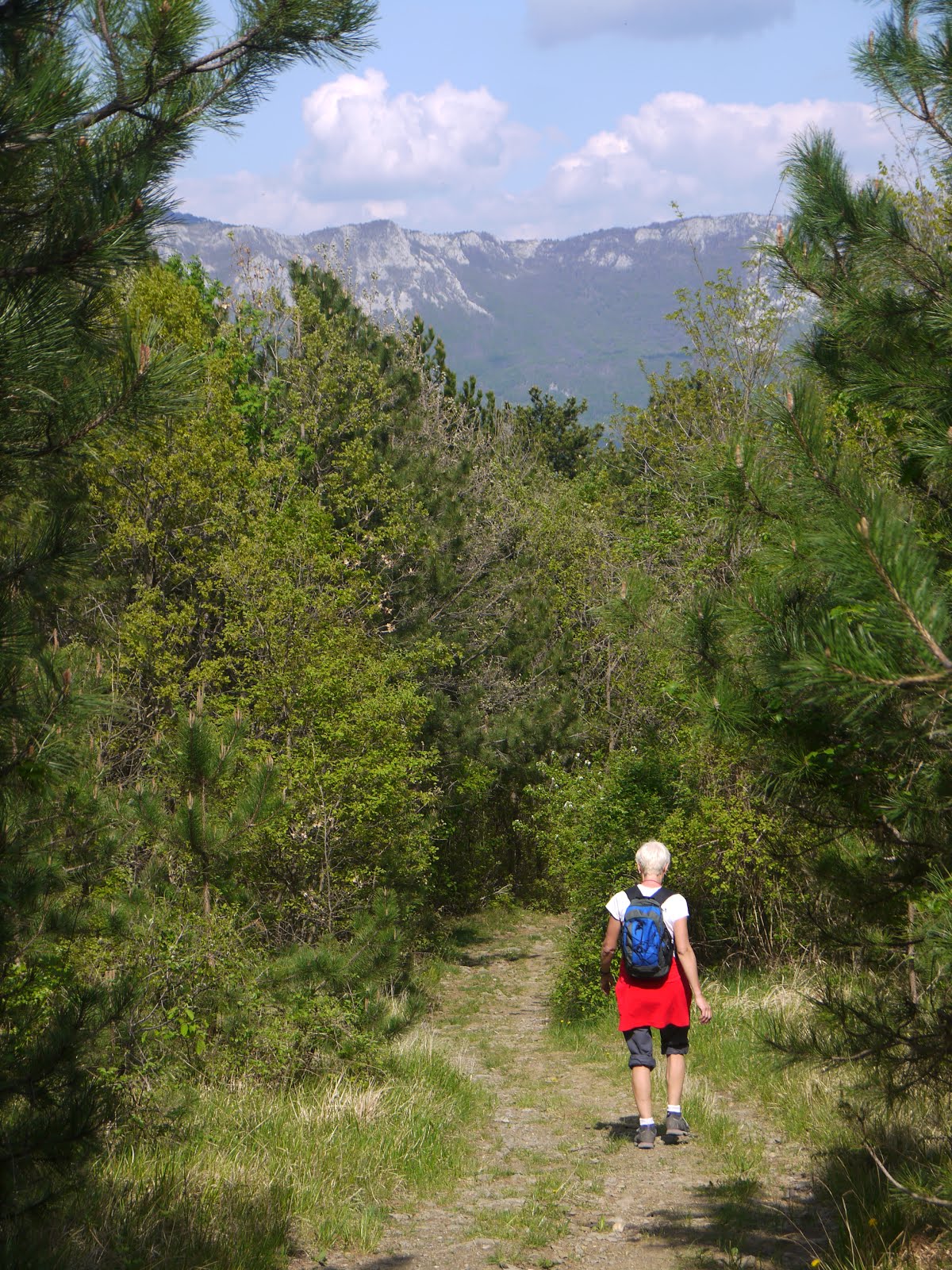
View of the Kamnik-Savinja Alps

The trail is called Pod Krošnjami or Under the tree crowns and goes from Church of St Mary of the Annuncition at Adergas to the plateau at Štefanja Gora, where you can visit St Stephens Church and walk amongst attractive alpine meadows towards Zgornja Štefanja Vas. If you have time you can extend the route to Sponja Štefanja Vas. There is also a longer route which starts at Cerklje na Gorenjskem.

The shorter walk (which we did) is around 4.5 miles, takes 2 – 2.5 hours. After an initial short climb, it is level with good paths. The extension is an extra 1.7 miles.

Both routes are available on Viewranger by following the links below:

Adegas to Štefanja Gora Plateau

Sponja Štefanja Vas extension

Getting to Adergas

As the Google map below shows, it is just a 13 minute drive north of the airport, via Šenčur. You drive across the plains towards Češnjevek, then climb steeply into Adergas. There is a large parking area by the Church of St Mary of the Annuncition and Monastery Velesov, both of which dominate this small settlement. There are signs in the parking area showing the walking route. 
Map showing route to Aldergas from airport
Map of route from airport to Aldergas

 
Map showing walking route
Photo of board by car park showing walking route

Our route

The walking route is well signposted. We went eastward along the main road and then followed the footpath signs along a residential road on the left, which climbs and becomes a track as it enters a forest by a house. 
 
House in Aldergas near track
House close to where we took the track into the forest

Picture of trees with light shining through them
View of trees as we entered the forest

After a short climb through the forest, we took a track to the left. A little further on we enjoyed some fantastic views of Aldergas and the surrounding plains.
 
View of Aldergas and plains from the track
View of Aldergas and plains
We climbed further up the track until it opened out onto the plateau close to Pri Mežnarju (a hiking hut and restaurant), with views of St Stephens church ahead.

View of St Stephen's Church


St Stephen's Church
St Stephen's Church

After stopping for some photographs, we walked up to the church, then towards Pri Mežnarju, which looked a nice place to for refreshments and a bite to eat:
 
Kmečki Turizem Pri Mežnarju
Štefanja Gora 28, 4207 Cerklje na Gorenjskem
http://pri-meznarju.si/
 
We then followed the road to Zgornja Štefanja, enjoying the lovely views of the Kamnik-Savinja Alps, with attractive meadows and the traditional Slovenia hay racks in the foreground. Below are some of the pictures I took as I walked:
 
 
Alpine view with hay rack.

Alpine meadow with trees and hills in the distance

Kamnik-Savinja moutains with hay rack in foreground

Alpine meadow, hay rack and St Stephens Church in distance

On reaching the outskirts of the village, we followed a track to the right, then took the second forest path on the right, which went westerly, then turned south westerly and downwards to meet the track where we had turned left earlier. We then retraced our steps to the start of the walk.

Refreshments

The closest place to Aldergas for refreshments is Cerklje na Gorenjsken. However, as we still has time before our flight, we had lunch at the Gostilina Pr’ Bizjak in Zgornja Bela (near Preddvor), as it had good reviews on Trip Advisor. We weren't dissapointed and it was particularly lovely sitting on the terrace enjoying the gardens.

Gostilna Pr' Bizjak: Zgornja Bela 20, 4205 Preddvor www.gostilnabizjak.si (15 minute drive from Adergas) 
 
We also had a flying visit to the Hotel Alma/Grad Hrib at Preddvor for a coffee, as I wanted to show Nicole this favorite spot of mine. I often go there for a drink or ice cream before flying home. The views of the lake and moutains from the Hotel terrace are spectacular.
 
Hotel Alma: Hrib 4a, Preddvor, www.hotel-alma.si
(10 minute drive from Adergas)

Lake and Mountains at Grad Hrib, Preddvor

7 June 2020

Memories of Lake Bohinj

Lake Bohinj: First impressions

I came across a blog on the top 10 things to do in Lake Bohinj this week.

Escape to Bohinj - top 10 activities at Lake Bohinj

It reminded me of my first visit to Slovenia back in 2001 with my husband Tony. We went on a 2 centre holiday, spending a week at Lake Bohinj in the Julian Alps, and a week on the coast in Rovinj, Croatia. We absolutely loved both areas, but particularly loved Slovenia. So much so that a few years later we took the plunge and brought a holiday home in Eastern Slovenia

If you were planning a trip to the Julian Alps, I would certainly recommend Lake Bohinj over Lake Bled.    

Looking back on that first holiday in Slovenia we stayed at the Hotel Zlatorog at the far end (Western side) of the lake. The hotel is now sadly derelict, which is a shame as it was such a lovely, peaceful location. 

Lake Bohinj from close to our hotel

At that time I always travelled with my trusty Pentax K1000. I have dug out some of the slides I took at the time and scanned them for this blog. The scan quality doesn't do them justice, but you will get the idea.

I remember making the short climb up to Savica waterfall and also walking around, and swimming in, the lake. There were few tourists at that time, so it felt like we had the lake to ourselves. We also hired a canoe, which was lovely at first. But then, after canoeing all the way from the Hotel to the village on the Eastern end of the river, it became choppy and windy, so the return journey was hard work.
Savica Waterfall


I also have hazy memories of a bike ride around the pretty villages in the area, sampling the various fruit brandies on offer.

At that time the cable car to Mount Vogel wasn't operating. Tony and I did try an ambitious walk up to Mount Voket (1489m) to the North of the lake. We had a grand idea of following the lake to the Eastern end from the summit, but it quickly became clear that it was overambitious. Dark clouds were also gathering, so having spent several hours climbing up, we climbed back down along the same route. 


Return to Bohinj


I have always wanted to go back, take the cable car up to Mount Vogel and try some walks from there. We did return briefly a few years later, when we decided to go for a long weekend camping. Having flown into the Ljubljana Jože Pučnik Airport at Brnik, we spent a lovely couple of days camping at Kamnik, visiting the wonderful Velika Planina

We then drove to Lake Bohinj and set up camp at the Zlatorog campsite. Unfortunately, shortly after we hitched up, the heavens open and we had torrential rain. Eventually, as the forecast was more of the same, we threw the wet tent into the back of the hire car and drove to a spa hotel in Bled, where we spent to last few days of the holiday, warming up.


I am determined to return to Lake Bohinj again one day. Reading the Escape to Bohinj website, it looks like Liz and Danny have done a fantastic job of renovating their holiday home in Stara Fužina, so it looks a tempting option for a future trip.


26 April 2020

Welcome to Love Walking Slovenia


Welcome to my blog. 


Most visitors to Slovenia head for Lake Bled, to enjoy the spectacular alpine region. However, there is much more to this small country, and if you venture further afield you will be treated with some fantastic walks, with beautiful, varied scenery, flora and fauna, but without the crowds and prices associated with more popular destinations.

Through these pages I am hoping to share with you some of the beautiful places I have walked in Slovenia.

When to visit


We have found the spring and autumn an excellent time to visit Slovenia. The weather is usually milder at these times of year. In the summer it can be very hot with thunder storms in the late afternoon. Whilst in winter it is often bitterly cold, with snow and the occasional violent storm.

In the spring you can enjoy an array of wild flowers, but tourist sites and facilities may not open until Easter. In the autumn, you can enjoy the warm, autumnal colours and the abundance of produce. Wine and fruit will be plentiful. There may also be a few festivals in late summer or early autumn.

We have had some excellent weather in April and October, but have also known snow as late as May! So whatever time you visit, be prepared.


Maps 

The KartoGrafija Tourist Maps (Turisticna Karta) 1:75000 / 1:50000 / 1:40000 show cycling, hiking and driving routes. They also have more detailed maps of the mountainous areas.

www.kartografija.si

It is often possible to pick up good maps showing local walks in the tourist offices. These are usually available free of charge.
 
I have used the Viewranger app to plot some of my routes. It has downloadable route guides, outdoor maps, and, for the techies, GPS navigation features. Some features are free and some are available at a small cost. You will be able to access my routes without any charge.

A small word of warning

Slovenia is generally a very safe place to travel. However I would just like to warn you about two creatures you may encounter:

Ticks

Ticks are very common in Slovenia. They carry Lyme Disease and Tick-Borne Encephalitis. Take precautions with a good tick repellent and carry tick removers. If you plan to walk a lot in Eastern Europe consider vaccination.

Snakes

Slovenia has eleven snake species, three of which are venomous. They won't kill you, but you will need medical attention if bitten. Read Total Slovenia News for advice on How to Deal with Snakes in Slovenia.


Lets get started...

I am starting with a walking holiday to the Vipava Valley I did in 2019 with a friend. Below you will find a link to a page about the region, where you will find further links to blogs on the three walks we did.


A view from Nanos, Vipava region

Walking the Vertovec Trail, Vipava region
Otlica Window walk, Vipava region

Coming soon

I have a holiday home in Velika Polana, in the Prekmura region of Slovenia. So I also want to share with you some of the walks I have done in the Prekmura, and surrounding areas. I will be posting these over the coming months for you to enjoy.


Find me on Facebook

You can follow the @lovewalkingslovenia Facebook page to get notified of updates to my blog.
 

25 April 2020

Ascending the Mighty Nanos

About Walking Nanos


Nanos is described as the most popular hiking trail in the Vipava Valley. It is a Karst Plateau, which provides stunning views of the Vipava Valley and Adriatic coast. The summit, at the Vojkova Koča hikers hut, is notable by the plethora of television transmitters, which can be seen from the E61 Motorway.
Nanos - view from motorway bridge at the start of the walk.

It is located on the edge of the Vipava Valley, less than an hour’s drive from the airport and just off the E61 Motorway at Razdrto.This makes the walk very accessible.

Those wishing to scale the 660m to the 1240m summit can choose the difficult, steep route, or a longer but gentler path. The walk is described on the Vipavska Dolina website (see below) as being 7.3km long and taking 3 hours. 

I completed this walk with my friend Nicole in April 2019, on the first day of our holiday in the Vipava Valley.  It took us two hours to reach the summit by the steep route and one and a half hours to return by the gentler path. 


Getting started

Start of Nanos walk
A parking area at the start of the route is signposted from the village of Razdrto and is located just in front of a bridge that goes over the motorway. Just over the bridge are some information boards about the Mast Road and history of professional Carters who used the road to transport goods since the 18th Century.  
 

Refreshments

The Guesthouse Mirjam, a 2 star hotel with camping,  is a good place to get refreshments (and possibly stay) before the walk. It is in Razdrto, on the left by the signpost where you turn off towards the walk start.

The Vojkova Koca Hut  on the summit provides food and shelter in season. It was closed in April ( low season) when we visited but was a nice spot to picnic. 

Our walk up Nanos

Having driven from my holiday home in the Prekmura, Nicole and I started by enjoying the hospitality and garden at Guesthouse Mirjam, before setting off around midday. Suitably refreshed, we started the walk at the car park, crossing the bridge, then turning left and then right to enter a meadow. After crossing the meadow, the path climbs through the trees. 
Starting the ascent through the trees


Decision time

After around 20 minutes we were faced with an intersection, with the choice of going left on the gentler (polozna) path or right on the steep (strma) path. 

My walking partner Nicole, coming from the French Alps, was keen to tackle the steeper route up. Whilst I, coming from flat Essex, was less sure, but decided to give it a go as I didn't want to appear a wimp. Nicole clearly found it a breeze, but I found it quite challenging as it did require quite a bit of climbing, particularly near the summit. However, by then I wasn't turning back, particularly as Nicole had made short work of it and had disappeared into the distance.  (So, if you have vertigo or don't like rock climbing, I would recommend sticking to the gentler path). 


Trees became shorter as we climbed

Upwards and onwards

We continued on following a rocky path through the forest. The trees are mainly deciduous and in April, there was little foliage, so we could see the views opening out as we climbed. There were also wild flowers and it was clear that a few weeks later the flowers would be even more spectacular. Although we were content to be able to enjoy the breathtaking views


Trees became shorter and more stunted as we ascended, bent and sculptured into interesting shapes by the Bora wind that famously batters the hills in this area. As we left the tree cover it became necessary to climb more and more. Steel cables and rods were provided in more difficult parts to assist hikers. There was one short area that was exposed with a significant fall risk (see photo).
Exposed area
 

The final climb

Care was needed on the final steep climb, as rocks were looser and some areas were marked Pozer! (Danger!) and so to be avoided. However, we were rewarded with spectacular views both on the route and on reaching the transmitter antennas. 
View from summit
view from summit as we started our descent

We stopped and ate our packed lunch on benches outside the Vojkova Koca Hut (closed at the time of our visit in April, but providing food and shelter in season), which is tucked amongst the trees.The ground under the trees was carpeted with wild garlic shoots, promising a fine display a few weeks later.


View looking back to the telegraph tower as we made our descent.

Our descent

From the hut there is a gentle descent along a ridge, with fantastic views over the rolling Vipava hills. It was late afternoon when we made our descent and the shadows and highlights created by the mellowing beams of light were particularly attractive.
Beginning our descent


First views of the Vipavska Brda as we descend

A lonely church

After 20 minutes we came to a point which overlooked the church of St Hieronim. nestled in splendid isolation amongst the hills. 


St Hieronium Church
As it was late afternoon, we didn’t visit the church, but stuck to the route, turning a sharp left and following the sign to Razdrto to continue our descent, whilst admiring wonderful views of the Vipavka Brda.


Soon we were back into the forest, following the attractive, tree lined path. At one point the trees were interspersed with massive boulders, which looked like they had been thrown there by a giant.


As we neared the bottom we briefly entered a meadow, which gave a good view of Nanos to the left and was carpeted with a variety of wild flowers. Then back into the forest, where we re-joined the path we had climbed at the start of the walk for the final 20 minutes.


Last part of the journey, returning through the meadow, wih Razdrto ahead.


On returning to the car, we had a 20 minute drive along the motorway, to our accommodation in a pretty village called Slap, close to the town of Vipava. We stayed at Na Hribu, a tourist farm offering a very reasonable dinner bed and breakfast. This proved to be a great budget choice and we enjoyed eating the locally grown fare and sampling the farmer’s wine.

Please read my Vipava Valley blog for more information on this region.

The Vertovec Trail - a walk among the vineyards and villages


About the Vertovec Trail Walk
(po Vertovčevih poteh)


This is a 10 mile themed walking trail, where Matija Vertovec, a famous priest, scientific writer, compatriot and teacher, worked and lived. The walk is  well signposted (po Vertovčevih poteh) and follows tree lined tracks, through pretty villages and to viewpoints with stunning views of the Nanos plateau and the Vipava Valley. It is described as an easy 4-5 hour walk. The walk is hilly, but much easier than Nanos.The majority of the walk is   off road and the variety of wild flowers and flowering fruit trees and shrubs along the route also made this walk very pleasurable. 
Views towards Nanos from Vertovec Trail


About our walk

This was the second walk, Nicole and I chose during our trip to the Vipava Valley. After scaling Nanos on the previous day, we wanted a gentler walk among the vineyards and villages of the Vipava valley. We took five and a half hours, which included a short lunch break and a detour up Ostri Vrh to admire the view.  

The walk was easy to navigate and there were signboards along the way. However they were not in English and were somewhat challenging for Google Translate. We found a leaflet in English at the tourist office the following day and was disappointed to find we had missed the opportunity to observe fossils en- route. The leaflet also promised home-made produce from farms on the route, although these were not evident in April 2019 when we did the walk. Fortunately, we took a packed lunch. There are also plenty of benches for resting and partaking in our refreshments along the route.

The starting point: Ustje

Start of walk
The walk started by an oak tree just outside Ustje, where there is parking available. Also, a signboard describing the route. We walked away from the village, to Dolenje, where we joined an attractive, steep, green lane that took us to the church of Sv Marjeta. Evidence of fossils can be seen along the route to Sv Martin. 

Leaving Ustje at the start of the walk


Dolenje
Green lane clinbing out of Dolenje


Sv Marjeta Church


The route climbs further to Nabojs, where we had a spectacular view of the Trnovo Plateau and Nanos. We then meandered through the attractive villages that make up the Planina region. Then, leaving the road, we joined a field track which led onto the Trešnik pass, 3090m above sea level.
Planina


Ostri Vrh

At this point, two hours int the walk, there was the short (10 minute) detour from here up Ostri Vrh (422m), (which translates aptly as “sharp peak). It was a brief, steep climb, which was rewarded by spectacular views showing the full extent of the Vipava Valley. This proved to be a highlight of the walk, providing a tranquil moment while we took in the views. We could easily have stayed there for some time. 


View from Ostri Vrh
View from Ostri Vrh

Descent from Ostri Vrh


Lunch at Šmarje

The walk then descended through several hamlets, to Jakulini, the birthplace of Matija Vertovec. We then followed the road to Šmarje. Here the walk took us through the old part of the village, which is preserved as a monument, with wooden balconies, projecting roofs, bridges and wells. We stopped at the churchyard, situated at a highpoint and enjoyed our packed lunch whilst admiring the views. 

This was the only area where we had a little difficulty navigating. We had to go through several small stone arches, one of which looked like it was being guarded by a big black bear, which fortunately turned out to be an old dog with no teeth. One of the villagers confirmed that we had to follow a track out the back of the village into a vineyard, which then curved back to the main road. 


Approaching Šmarje
Šmarje

An ancient track with fabulous views

We followed the road, climbing to Vrtvče, where we were pleased to join an ancient track which slowly descended to Vrtovce, offering fantastic views of the Trnovo (Thorn) Plateau (Trnovska Planota) to our left. From there we returned to our starting point, Uhanje.


Trnovska Planota


Trnovska Planota


Ancient track  to Vrtovce


Returning to Ustje


Please read my Vipava Valley blog for more information on this region.